
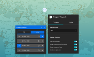
Bring time into your map with the Imagery Wayback widget. This tool connects to Esri’s World Imagery Wayback archive and lets users view past versions of satellite imagery directly in your ArcGIS® Experience Builder apps. With just a few clicks, users can identify when changes occurred at a location and compare different points in time.
Whether you’re monitoring urban development, checking environmental changes, or simply curious about how an area looked before, this widget makes visual time travel easy and interactive. Choose a date, explore updates, and even compare two imagery versions side by side using the built-in slider.
What it helps you do
Key features
Example use cases
Using ArcGIS Online?
If you don’t have access to ArcGIS® Experience Builder Developer Edition, try our Hosted Experience Builder environment. It’s the fastest way to start using custom widgets like this one – no local setup or deployment required.